Saraichik
Ancient settlement of Southern Kazakhstan
"On the tenth day after departure from Sam we arrived at city of Sarajuk, where juk means "small".
They thus wanted to express that it was a Small Sara. The city is located on the bank of a deep, large
river called Ulusy, meaning "great water". A pontoon bridge is thrown across it, the same as in Bagdad.
In this city our travel on horses pulling bullock-carts finished. So we sold them for four dinars
per horse, considering their weakness and cheapness in this city, and hired
camels to pull our carts. There is an inn of a righteous old Turk man in this city, who is called
ata, which means "father". He treated us in the zavia and blessed us. The cadi of this city met us too,
whose name I do not remember now."
Ibn Battuta. "Travel"
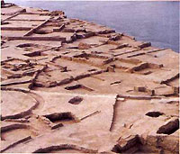 Within 50km of the modern city of Atyrau, on the right bank of the river Zhaiyk, are ruins of a once majestic and famous city, Saraijuk (present name - Saraichik). According to one historical version offered by Abulgazi Bakhadur-Khan (1644-1664), the city was founded by Batu (ruled from 1227-1255), brother of Berke (1257-1266). Abulgazi states: "Berke-khan, when he became khan, ... ratified the domains given to him by Batu-khan. He sent large gifts to the Khan. One day, The Most High Lord (Allah) poured the love of Islam in the heart of Berke-khan, and he learned that his belief had been untrue..."
Saraijuk, alongside other cities, was founded in the first decades of the life of the empire of the Zhoshi Ulus, which later was referred to as the Golden Horde, in order to control the huge territory from the Irtysh River to the Danube. Initially, these cities served as points with palaces and administrative buildings for the aristocracy and supervisors of the territories under their control. Step by step, buildings were surrounded by dwellings of various people: craftsmen, free citizens, merchants, etc. Saraijuk was one such city. Built on a central, in the strategic sense, site at the junction of Europe and Asia, it ensured the safety of the segment of the Great Silk Road between European countries and the capital of the Golden Horde (Serai-Batu and Serai-Berke) on the Volga to the cities of Khoresm, Iran, India and China. Descriptions and stories of many merchants and travelers have survived through the ages, describing the direction of this path, the character and price of goods, and methods of transportation. The trade route from Sarai to Saraijuk and further to Urgench was outfitted with wells and caravanserais. In the 13th and 14th centuries, it was the major route connecting East and West.
Thanks to this circumstance, talented masters from famous architectural schools erected magnificent palaces, caravanserais, baths, mosques, madrasahs and other magnificent buildings in Saraijuk. The city had a well-developed layout with straight wide streets and squares. Oriental influence is especially visible in the shape of the city. Proceeds from caravan trade, war trophies, tributes from conquered nations and plenty of cheap labor promoted the fast growth of Saraijuk. The absence of fortified walls facilitated the fast expansion of the city limits. Without them, cities always were under the control of the Khan's authority. They had to take side of the winner in the struggle for the Khan's throne, while the winner was required to ensure their safety. From the moment of its foundation, Saraijuk appeared at the center of intra-horde and international events - from the court dynastic struggle of representatives of the Zhoshy House for the throne, to military riots and political intrigues, growth of trade, economic, cultural and other ties, and the disintegration of empires and formation of new ethnic groups.
 In the course of archaeological research from 1996-2000, three stages of the city's life were determined. The earliest dates to the first decades of its existence. Saraijuk's central core at that time was formed of buildings built mainly from adobe bricks. Further to the south, these smoothly transformed into suburbs filled with juris and wood framed structures. This segment stretched along the river. Researchers know its width, about 300 meters. The length, judging by the development of the city in the next few decades, was several times greater.
In the second period, starting from the 1330s, the city, under the influence of various factors, was arranged around its central section of brick structures, and had been extended onto the island between the channels of the Zhaiyk River. Thus, it was possible to supervise all movements of people on the river near the city. The peak of the city's development was in the 14th century. In the 15th and 16th centuries, the layout of the city changed again. Its core gradually decreased in size and was shifted to the southeast, closer to the Zhaiyk's side channel, Sorochinka. During the past two centuries the river Zhaiyk has changed its course several times. Every year, during spring floods, the river erodes significant areas of the city's cultural layers. At present, the area of the remaining part of Saraijuk, excluding the adjoining area and ancient necropolis, accounts for approximately 600 x 600 metres.
 In 1950, А. Kh. Margulan raised the question of the necessity of a prompt complex of research on the Saraijuk city ruins because of the continuous erosion of its cultural remains by the river Zhaiyk. At the same time, it was ascertained that the Ural River was already approaching the center of the ancient city. In that year, an archaeological expedition under the leadership of A. Kh. Margulan was organized. It worked only one field season and the results of the expedition are, unfortunately, not completely published at this time. After that the problem of the study and rescue of the remaining parts of Saraijuk dropped out of sight for many years, despite some attempts in the 60-80s. Realization of the historical importance of Saraijuk and its special role in the initial period of formation of the Kazakh state system and exclusive importance of the cultural heritage of ancestors for spiritual ties of generations resulted in the creation of a memorial museum complex, consisting of a symbolic pantheon, museum of archaeology and a mosque.
During stationary research carried out by the Western Kazakhstan expedition of the Margulan Institute of Archaeology under the leadership of Zeinulla Samashev in 1996-2000, scientists uncovered significant finds in different areas of the ancient city, mostly from the first period. Houses of the first inhabitants were discovered. Most likely, the construction of the city was carried out under a uniform plan, considering traditions of nomadic city construction. The houses found at the spot were made of adobe brick and had two to four rooms of 4 x 5 meters in size. A sofa-type stove/bench placed along three walls of the rooms was a common feature. It had a size of 1.5 to 2 meters in width and was warmed by built-in horizontal flue channels that ran from the tandyr fireplace via a vertical passage in the wall to the chimney on the roof.
 All walls and sofas were covered with a layer of clay plaster and whitewashed. Remnants of a felt carpet were found on one of the sofas. The floors were made of rammed clay. Coverings of reed mats were preserved in a number of rooms. Arched niches arranged in walls above the sofas were probably a place for candlesticks, expensive crockery and other household things. Beside the living quarters, houses had pantries with special pits for millet and barley; also there were places for storing plums, apples, and grapes, whose seeds were found there, and even almonds brought from faraway countries. A dried onion was also found there. Storehouses were partitioned from heated living quarters by walls made of wooden frames with adobe bricks arranged in a herringbone pattern. Such a design was decorative and served for natural ventilation in the storehouse.
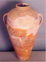
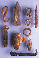
Crockery found in the rooms included clay jugs, pots, kumgans and boilers, various in form and made by local craftsmen. These were supplemented by jugs made of kashin (special light ceramic paste, a silicon derivative with sand, kaolin and feldspar as major components), and covered with shining turquoise enamel, obviously of local production. An Ibis set of utensils was decorated with stone boilers brought from Khoresm, multicolored enamelled kashin cases brought from cities on the lower Volga, as well as fragments of cups of very expensive greenish Chinese celadon, for which the local rich would pay big money. The city had workshops for manufacturing bone products. Various buckles, facing plates for bows, articles of quiver decoration, knife handles, rings for archery, tanning and weaving tools and other items were made by talented craftsmen. Tanners' products were high quality: purses and belts, ichigis (woman's soft leather boots) and heeled boots composed of dozens of leather layers, jackets, water-skins and saddles.
The economic activity of the townspeople also included breeding excellent horses and hardy camels, so necessary on distant caravan routes. According to Ibn Arab-shah, an Arabian historian of the 15th century, caravans passed from Khoresm absolutely peacefully, "without fear or dread", up to the Crimea within three months. "Caravans carried neither foodstuffs, nor forage for horses with themselves and did not hire a conductor, owing to the large number of peoples (living there), as well as the abundance of security, foods and drink that could be provided by the people (living there)". The citizens of Saraijuk were characterised by a high level of literacy. This is demonstrated by the variety of inscriptions on utensils, bronze items, and simply on paper. They were especially well-preserved on ceramics. One of the clay khums is decorated with fragments of a poem by Uysuf of Balasagun, born in the Chu valley and living in Kashgar in the 11th century:
- "The beauty of a person is the face.
The beauty of the face are the eyes.
The beauty of the mouth is the tongue.
And the beauty of the tongue is the word".
 Active trade was conducted with China, the Caucasus, Iran, India, Central Asia, Eastern Europe, the Crimea and Russia. Chinese porcelain was a decoration of rich citizens' dastarkhans (tables). This high-quality porcelain is represented among Saraijuk finds mainly by utensils of light-salad color, which was called celadon in Europe. It was decorated with the finest ornamentation and sky-blue paints. Along with various plant ornamentations decorating the products, such as clouds, birds, etc, archaeologists found fragments of cups with hieroglyphs. Iranian and Syrian glass jugs, cups, lamps with painting made with the use of multicoloured enamels and gold were an eye-pleasing goods. Gracefully trimmed Khoresm stone boilers were highly valued by citizens; they believed that food cooked in them received a special, very pleasant taste. Original vases, cases and dishes made of black clay and covered with glossy ornamentation which shined in the sun were also brought from Khoresm.
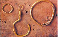
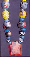
Necklaces from glass, cornelian and crystal beads, and mountings from turquoise for rings were made in Saraijuk or brought from Iran and Central Asia. Magic "kauri" bowls were brought from India; amphorae brought from the faraway Black Sea trade city of Trapesund were used for transportation of wine and oil. Magnificent Crimean enamelled dishes were brought here in caravan bales and in ship holds. Multicoloured keses and pialas with inscriptions of religious and philosophical ideas that were brought to Saraijuk from Khorasan and the cities of the lower Volga were used in the households of local inhabitants. Magnificent enamelled dishes and vases made by local masters decorated the homes of other cities of the Golden Horde. One such vessel even appeared in the collection of the State historical museum in Moscow.
The third stage in the city's life falls at the turn of the 15th and 16th centuries. There was a change in the topography of Saraijuk. Inhabited sites located along the Zhaiyk were deserted, and the population began to concentrate in the southern area of the city, along the channel of the river Sorochinka, which is now dry. The channel surrounded the city from the west and flew out of the Zhaiyk at the city's north-western border. It is likely that natural changes occurred in the river's channels.
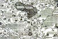
 The ambassador of Austria in Muscovite Russia, Sigizmund Herberstein, wrote in 1549 that Saraichik was owned by prince Shidak at that time, and mapped the city on the left bank of the river Zhaiyk. The same location was drawn by the English merchant, Anthony Jenkinson, who visited the site in 1558. At that time, Saraijuk became the capital of the Nogai Horde. The tribe of the Mangyts then dominated the horde, and the term "Nogaians" appeared only in the 16th century. The majority of the territory of the Nogai Horde lay in the steppes between the Volga and the Zhaiyk. The structure of the Nogai Horde included over twenty tribes and clans: Naimans, Kypchaks, Alashes, Kangles, Alchins, Konyrats, Katagans, Uigurs, Tkais, Mangyts, etc. This association was not ethnic, but political.
The residence of the head of the Muslim clergy of the Nogai Horde was here. The Nogaian governors and mursas considered it important to have their daughters married by Seids living there. Seids are considered descendants of the prophet Mohammed and constituted an especially respected clergy group. Along with the Seids, other categories of Islamic clerics resided in Saraijuk: sheikhs, mullahs, hadjis, haphises, sufis, and dervishes. This tradition was probably established upon the adoption of Islam in the 13th century. The clergy comprehended and interpreted different situations and gave moral advice to statesmen; it was involved in diplomatic negotiations and actively participated in the life of the city and steppe as "people's teachers". Many of them lie in the earth of Saraijuk. Along with them, Nogaian princes and murzahs found their last home here. According to indirect data, the bodies of famous governors Okas, Shikh-Mamai and other noble people are buried here as well.
Human memory has retained the beauty of human images in poetic form:
- Saraichik's songs
"Are like the goose's scream,
Nogaian girls are so generous
That they give honey to those thirsty for water".
 At the present time, the site is quickly disappearing from the face of the earth. This process is connected with the change of the course of the river Zhaiyk. The powerful flow of the water has begun to intensively wash away any trace of its past. Therefore, the purpose of this article is to bring a sliver of the deep historical memory of its people to present and future generations. The layers that remain of the life of Saraijuk are a book, which has forever retained happiness, love and hatred, the welfare of the townspeople and nights of defeat, troubles and diseases.
Each item, extracted with great effort and saved for us by nature, be it artistic ceramics, plates with mythical images, decorations, coins and other items, carry a flow of information from that time, which we can not completely decipher yet, and reflects the huge spiritual world of our ancestors. Saraichik and its vicinity has always been a battlefield of geopolitical interests of the Caspian zone countries, as well as of the East and West in general. As the historical fates decree, its special binding role in the maintenance of economic, cultural and political ties has now passed on to the city of Atyrau, located near the ruins of the ancient city. Atyrau, a powerful oil production and trade city, has a long future, which was predetermined by nature's favor to this part of the Earth, and by the results of the fruitful efforts of our ancestors.
